Which Way the Wind Rose?
I found a cool tool. Ever wonder which way the wind blows at your stand? No, I don’t mean sticking your finger up. I mean, statistical historical data on exactly how often the wind blows from a given direction near your hunting location. I’m talking wind roses.
Here are the steps:
- Find out the closest airport to your location: https://www.travelmath.com/nearest-airport/
- Go to the climate site: https://mrcc.purdue.edu/CLIMATE/
- You will have to set up an account the first time through. It’s no big deal.
- Pick “Wind Rose” — the choice in the upper right corner.
- Click on Select Hourly Station in the upper left hand corner and input your airport from step 1.
- The rest of the input looks complicated, but it’s not.
- You want to set date range to as long a time scale as possible– 1996 to present
- You want to set the sub interval window for the date range you want to view. Pick a week or a month during hunting season.
- You can limit the data to a specific time window.
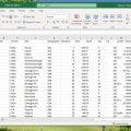
Here is the result for picking my nearest airport, LUK, and a date range of 11/8 to 12/1, the limits of the Kentucky Rifle Season and 0600 to 1900.
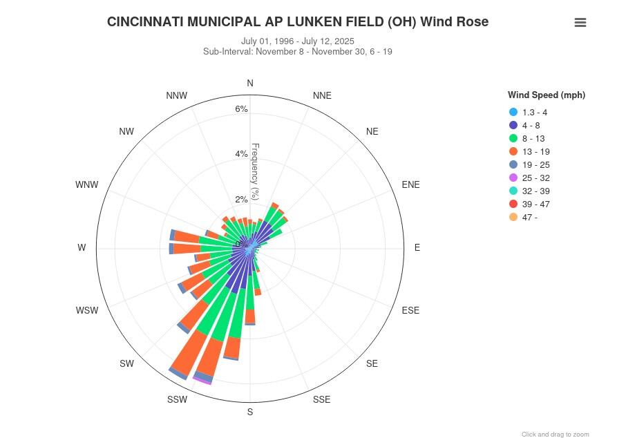
I think it’s easy to see most of the wind comes from the South-Southwest. It almost never comes from the East or North. I kind of knew that already, but I’d never seen it displayed. Your area may be totally different
This post has already been read 7888 times!
Visited 17 times, 1 visit(s) today
Views: 67


Comments
Which Way the Wind Rose? — No Comments
HTML tags allowed in your comment: <a href="" title=""> <abbr title=""> <acronym title=""> <b> <blockquote cite=""> <cite> <code> <del datetime=""> <em> <i> <q cite=""> <s> <strike> <strong>